Mapping Planetary Urbanization
Symposium and Workshop:
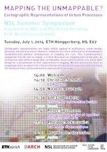
Mapping the non-mappable? Cartographic Representations of Urban Processes
Summer Symposium
Organizer: NSL (in collaboration with the FCL Module V Summer School on planetary urbanization)
Time: 14:00–19:00, Tuesday, July 1, 2014
ETH Zurich
HIL E 67
Stefano-Franscini-Platz 5, 8093 Zurich
Presentations by: Nicolas Bourquin, Jan Lindenberg, Philippe Rekacewicz, Christian Schmid, Peter Spillmann
Cartographic representations are today widely applied in architecture, urban design, planning, and social sciences. However, moments of critical reflection on methodological foundations,and political consequences of mapping are rare. This transdisciplinary symposium has the aim to engage a critical discussion on mapping and cartography, by inviting four specialists in geography, cartography, visual representation, arts and graphic design for a presentation of their experiences in mapping. We will particularly focus on mapping practice as a device for critical reflection of urbanization processes and investigate the notions of time, clarity and intuitive imprecision in the maps.
Themes:
— discussion of different forms and means of cartographic representation and their effects.
— possible consequences of producing visibility through mapping exercises
— limits of the cartographic method (cartographic silences, mapping the non-mappable?)
— hierarchies of representation (e.g. center of the map, projection, orientation).
— differentiation between analysis of built environment and analysis of urbanization processes;
— differentiation between temporal and spatial level of interpretation
— legibility of maps and reasonable density of information despite superimposition of different levels of data